An internet-connected network of cameras and sensors in five states taps into the power of crowdsourcing and allows wildfires to be spotted quickly and more precisely. Graham Kent, the seismologist who helped create the system, explains how it works.
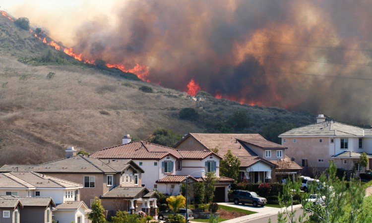
A year ago, a grim new record was set. In November 2018, the Camp Fire in northern California became the deadliest and most destructive wildfire in the state’s history, burning the entire town of Paradise to the ground and killing an estimated 86 civilians. And it was just one of several record-breaking wildfires to tear through California in the past few years. “This is the new normal, and it’s not acceptable,” says University of Nevada, Reno, professor and seismologist Graham Kent in a TEDxUniversityofNevada Talk.
Wildfires have long been a regular occurrence on our planet. However, due to drought, rising temperatures, and increasingly unpredictable weather patterns, today’s fires are bigger and more destructive — and many scientists are predicting they could get even worse. Exacerbating the situation are mismanaged forests and an increasing number of people living in high-risk areas. As a result, the financial and human costs of recent fires have been unprecedented. In 2017 alone, damage from wildfires across the US exceeded a staggering $18 billion. Other parts of the world are being hit hard, too. This past summer, Spain suffered the worst wildfires that it’s seen in 20 years, while thousands of fires burned in the Amazon Rainforest, an increase of over 80 percent compared to the same time period last year.
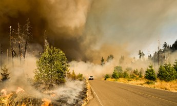
When it comes to fighting wildfires, every second counts. At its peak, the Camp Fire is estimated to have burned an area greater than one football field (roughly 1.32 acres) in a single second. Early detection is the key to ensuring that fires are kept under control and properly extinguished. The longer it takes dispatchers to locate a fire, the harder it is to contain.
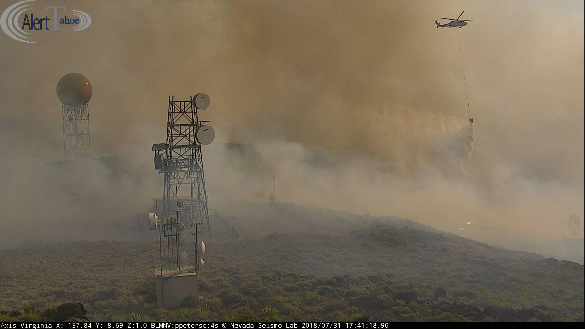
What if technology could help people detect wildfires earlier? That’s the aim of ALERTWildfire. ALERTWildfire is a network that collects and receives real-time images and data from cameras and sensors in California, Nevada, Oregon, Washington and Idaho. It’s broadcast via the public ALERTWildfire website, which means anyone can be a fire spotter by going online, selecting an area of interest in those five states, and monitoring what’s happening.
Wildfire detection has traditionally consisted of lookout towers. Perched in remote areas, these small structures hold a single human who’s charged with summoning help at the first sign of trouble. Unfortunately, these lookouts come with a few serious drawbacks. They’re difficult and expensive to maintain, and in an emergency, they’re treacherous to reach and escape from.
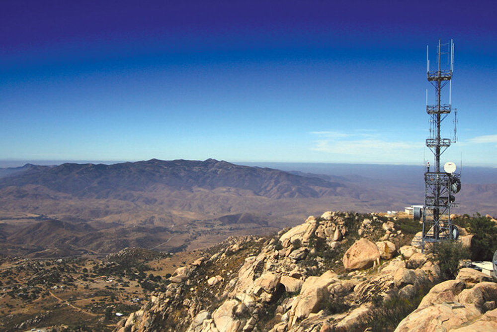
ALERTWildfire’s cameras and sensors are placed in similarly far removed locations — but no humans need be on hand. Drawing on the work of multiple collaborators, Graham Kent helped create this system. After he lost his home to the 2003 Cedar Fire in San Diego, he became involved with cameras that monitored wildfire progression in his area. When he moved to Reno, Nevada, in 2009, he was determined to pioneer a better approach to spotting wildfires — by using cameras on a publicly available network that could be controlled at a distance to zoom in and get a higher-res image of a fire as it started (as opposed to cameras that remain in a single fixed position).
That same year, he learned about a group of young students from Meadow Vista, California, who won the FIRST LEGO League Children’s Climate Call competition with a project called Forest Guard. Forest Guard was motivated by the students’ personal experiences — they’d been forced to evacuate their homes the previous year due to a forest fire — and they showed how solar-powered cameras that could pan, tilt and zoom (PTZ) might be deployed for early fire detection.
Kent worked with them and their advisor to develop a new prototype system, and in 2013, AlertTahoe — a pilot program which used internet-connected PTZ cameras to monitor the Lake Tahoe Basin, capture images of wildfires, and transmit them over microwave networks — was launched. AlertTahoe served as the foundation for what became ALERTWildfire, and in six years, it has detected and extinguished more than 50 fires in that area.
Building on the students’ idea, Kent and his team at the University of Nevada, Reno, added two important features: internet connectivity and crowdsourcing. Thanks to these improvements, the cameras could capture and stream live, high-quality images to a website and dispatchers could pan, tilt and zoom the cameras to get the best view of the fires. The internet connection also meant the system could be publicly available so that people anywhere could be part of the fire-spotting process and boost their situational awareness — the ability to understand and assess what’s going on and respond appropriately— which is essential to surviving a disaster such as a wildfire.
By the mid-2010s, promising results from AlertTahoe attracted the interest of federal agencies, universities (most notably University of California, San Diego, and University of Oregon), public utilities, technology partners, and other organizations. Private companies that owned communication towers allowed ALERTWildfire to install cameras and sensors on their structures. Thanks to this increased funding and resources, ALERTWildfire grew into a multi-state network. Today it consists of more than 1,000 cameras spread out over five states (California, Nevada, Oregon, Washington, and Idaho).
One of ALERTWildfire’s greatest contributions is providing improved fire detection when visibility is low. Upon nightfall, ALERTWildfire cameras are able to shift to near-infrared vision. Such thermal imaging allows dispatchers to pick up changes in heat, permitting fires to be detected even when smoke can’t be seen. “The near-infrared allows us to do a really good job at night,” says Kent.
The near-infrared cameras have been incredibly useful in southern California where sundowner winds are often followed by Santa Ana winds, especially in the fall and winter. Sundowner winds occur at dusk when a gust of high pressure forms north of Santa Barbara and interacts with the Santa Ynez mountain range, creating warm, dry conditions. When the Santa Ana winds — northeast gusts that can exceed 40 miles per hour— also kick in, this combination can quickly fan small sparks into destructive blazes. “These sundowner events are, in a sense, the most greatly dangerous times for quick-fire ignitions, yet they’re very easy to spot,” Kent explains. All it takes is a little training to recognize the flickering light of a fire at sundown, and they can be spotted via the ALERTWildfire cameras.
So what does ALERTWildfire look like in action? Before the system, people would call 911 when they saw signs of a fire. While they’d do their best to report where it was, it was often hard for them to pinpoint the precise spot. With fires that are within the range covered by ALERTWildfire, dispatchers who receive a 911 call can pan, tilt and zoom the cameras on the network to find the exact location in real time and understand its magnitude. Then, they notify emergency responders who can determine whether firefighters should be sent, how many, and where they should go.
“Without a system like ALERTWildfire, responders don’t really know what’s going on,” says Kent. “They’re potentially sending resources to the wrong area, or it might not even be a fire.” He adds, “90 to 95 percent of the time, the greatest advantage that ALERTWildfire can provide to dispatch is just that quick confirmation.” From 2016 through 2018, the ALERTWildfire network helped spot and manage more than 900 fires.
While the location info from the cameras is incredibly important, crowdsourcing plays an equally pivotal role, emphasizes Kent. Crowdsourcing, such as in the form of Waze — the platform which lets users report traffic jams and accidents to a database that anyone can access — has changed the lives of drivers around the world. Waze taps into the power of the crowd and allows them to share their firsthand knowledge so everyone can benefit, and that’s what ALERTWildfire is trying to do, too.
Of course, crowdsourcing depends on a crowd — it works only if enough people are involved and engaged. Recently, a team of 100 Orange County, California, volunteers (led by Neil Driscoll at UC San Diego) was online monitoring the ALERTWildfire cameras in shifts on high-risk days. Although wildfires have been known to strike the state throughout the year, summer and fall are when residents are especially wary.
ALERTWildlife’s future success also depends on additional innovations in technology. Crowdsourcing is so important because cameras and computers aren’t yet capable of detecting fires on their own. Kent and his team are working to develop the kind of artificial intelligence that can spot wildfires, and to do so, more cameras are needed to collect more images and more data so they can teach AI how to visually recognize early fire warning signs, such as flickering light, the emergence of smoke, and heat signatures.
In addition, Kent and his collaborators want to increase the number of sensors on the network that monitor air quality, flood data, and seismic data so they can better track all kinds of environmental threats. “It’s important to not just build a camera network or a seismic network or a flood network or an air quality network,” he says. Instead, one day, he’d like to see a single platform that could collect and interpret all kinds of information and alert people to a wide variety of impending emergencies.
ALERTWildfire is very much a work in progress, yet Kent and his team are hopeful. “This system won’t allow every fire to be knocked down, and it won’t save every person in the future from being injured or worse but it will help some of them,” he says. In the meantime, the system needs more people watching in order to catch more fires.
After all, the network contains over a thousand cameras, with more being added. “There’s not enough personnel at the dispatches around the country to do that level of inspection,” Kent explains. As he says in his TEDx talk, “We need your help. We need you to volunteer, have neighborhood watches, jump on these cameras, and help us get a start that knock down those fires early.”
To get started, go to ALERTWildfire.
Watch his TEDxUniversityofNevada Talk now: